
Here is a post to answer one of our more frequently asked questions.
Q: How do we decide where to go and what to do next?
A: (1) Cyclone Seasons/Weather; (2) Circumnavigation Budget Timing; (3) Sailor Hodgepodge (4) Local Word of Mouth, and of course, (5) Travel Magic.
You may have perused oddgodfrey.com's Site Map in the past. But if not, it’s a good place to go to see the big picture of this trip. We have a photo of our original route plan. In theory, our travels are broken down into hemispheres: New Zealand by November 2016; Thailand by November 2017; South Africa by November 2018, Mediterranean by May of 2019, the Caribbean by June 2020, Panama Canal by December 2020; and San Diego by June of 2021. Why? This is because each of these deadlines keep us cruising in areas where the weather is at its best, and allows us to escape areas/seasons most at risk for hurricanes, cyclones, and typhoons (same weather system, different names based on area of the world). These deadlines are also based upon the need to return in five years give or take based on our budget and our apparently problematic scuba diving addiction.

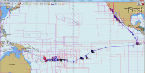
Now, we have a few photos which depict the actual route we have taken. As with anything in life, nothing goes entirely 100% to plan. Instead of reaching New Zealand by the end of 2016, we left Sonrisa in Tonga, moved Fiji and Vanuatu into 2017 and are now in the process of figuring out what to do with Australia. We may be deleting Australia for now, leaving that for a road trip or other vacations later in life. It’s just too big and too expensive to travel it properly this year.
These maps are really only the big picture. Once we get to an area, we have to decide which islands to visit, which anchorages within the island, and what to do while we are there. This is the tricky bit, because no matter how fast you move or how long you have, you cannot ever see it all. Indonesia has 17,000 islands. We could not stay in every beautiful anchorage in Indonesia if we stayed and sailed there for the rest of our lives. The best we can do is select a route that will give us a good taste of the nature and culture of a place, and enjoy what we can given our big picture schedule. In the interest of time, we don’t try to rebuild the wheel doing our own raw exploring.
There are all sorts of guides out in the published world. Lonely Planet can be helpful for land travel, but they are expensive and often not the best for sailors. They don’t have any information about navigation issues or anchorages, leaving us to figure out where to put Sonrisa and how to get from an anchorage to the place the guide suggests. So, we rarely use published guidebooks.
Instead, we use the hodgepodge of information circulating amongst sailors. Sailors love to tell each other everything they know about a destination, so it doesn’t take long after sailing in to port to get the “full report” on practically everything. Usually, one or two sailors have been sailing this particular island group for the last ten years, so they are full of “can’t miss opportunities” built into their efforts to shame us for moving too quickly. “You can’t spend only six weeks in Fiji! You will miss all these wonderful places…..” We immediately make a list of the wonderful places they are worried about and slot them in as best we can. Sometimes sailors circulate horrendously out of date local guidebook for every area you visit. We were handed the 1991 Edition of the "Rocket Guide" also known as the Tusker Guide. It provides the coordinates and a review for safe anchorages. An updated version of the guide is available, and that is probably advised, but these areas of the world change so slowly that most of the information in the old guidebooks remain accurate. They usually include culturally sensitive hints that help you insert yourself into a new culture with minimal trauma. For example, in Vanuatu we learned that the locals own not just the land, but all the way out onto the reefs. Before you go snorkeling, diving, fishing, or the like, you must go to shore, say hello and ask permission. You cannot walk through Ni Vanuatu’s villages without a guide, you should not try to give gifts unless it is to the village as a whole, but be prepared to trade.
We check local tourism offices and local websites, just to make sure we aren’t missing some cultural festival or other event being publicized by locals. We also ask someone who really knows. Of course the locals have their own opinions about their “can’t miss” experiences. At the first local’s hangout we can find, we ask what we should do while visiting their beautiful island or country. It always results in a big smile, lots of hints, and sometimes even a new friend.
If all else fails, we review the Soggy Paws Compendium - a famous-amongst-sailors collection of writings about various Pacific destinations. http://www.svsoggypaws.com/files/index.htm S/V Soggy Paws is a catamaran out and about sailing the world. Lacking a central location for good sailing guides, the Soggy Paws Crew made PDFs where sailors can send in write ups about their experience in various countries. You can read and peruse other sailors experiences and get an idea of dive sites, anchorages, navigation aids, fun land travel to do, safety warnings, where/how to get fuel, all sorts of good information. Quite handy.
All of this happens over the course of our whole time in a country. We rarely enter the customs check-in with a real plan. We have a vague idea of where to start, and then we formulate the real plan as we go. Flexibility, openness and the understanding that we will never be able to see it all is key to avoiding frustration.
One night in Port Vila, Andrew cracked open the Tusker Guide, Circa 1991 and started getting an idea of the can’t miss opportunities in Vanuatu: the volcano in Tanna (check), steak cheese and coffee in Port Vila (check), top notch wreck diving in a World War II transport ship, cocoa plantations, sand painting, friendly “yacht clubs.”
“Divers travel from all over the world to dive on the Calvin Coolidge and give a sculpture left inside - The Lady - a kiss for good luck.” Andrew reads. I know where we are heading!
“Quartz stones can easily be found on the beaches of Malakula. Locals believe these rocks to have the power to bring thunderstorms and rain during the dry season.” The author of the guide describes how, though filled with disbelief, he gathered his own magic rocks. Years later, while sitting in Port Vila on a nice, safe mooring, he smacked the rocks together as instructed. Little blue sparks filled the rocks, magic? Nothing happened, until a few hours later dark clouds rumbled by bringing thunder, lightning and rain!
“Oh, we need to go get ourselves some magic rocks,” Andrew declares.
Sonrisa was not particularly impressed. “You want to bring rocks aboard that have the power to bring storms?”
While ashore, we heard talk of Dugongs, a large animal related to a manatee. “You can swim with them!” We are told. Andrew googles the Dugong and learns that they are friendly and curious - so friendly and curious that sometimes they like to give swimmers a hug, pulling them underwater to see how long they can hold their breath. “Oh, we need to find some Dugongs!” He declared.
I was a little concerned: “You want me to swim with a giant sea animal offering death-hugs?”
In his search for Festivals and Events, Andrew found information about the Fanala Festival on Ambrym Island: black magic, drumming, custom dancing, intricately carved masks and “the most powerful sorcerers in Vanuatu” said the website.
“We have to go see sorcerers!” Andrew proclaims.
While I write blog updates, he takes to the navigation charts and plots a circuit of our time in Vanuatu: Tanna — Efate (Port Vila) — Emae— Epi — Malakula — Santo Espirito — Maewo — Ambae — Pentacost — Ambrym, then back to Efate to check out. We cast off in search of more volcanos, magic rocks, dugongs, deep sea ladies, sorcerers, sand artists, mask carvings, and whatever else might pop up in our wanderings. Here we go!

Blue lines are our planned waypoints. Red or purple lines are our actual course as sailed.